The Glacier That Fell on Nepal Might Also Be Bangladesh's Problem
A glacier collapse in Nepal killed over a thousand people in August. The water that caused it flows through the same mountain range as every major river Bangladesh depends on.
In June, the Telegram founder Pavel Durov opened a speech at the Oslo Freedom Forum with a story about a ship that had already hit the iceberg.¹ The Titanic did not sink in an instant, he pointed out. It sank slowly enough that most passengers spent the first hour believing the band was still playing for them, not for a crisis. Lifeboats left half full. Panic arrived in the last thirty minutes, long after the decision that mattered had already been made.² Durov was talking about digital surveillance. I keep thinking about it in a completely different context.
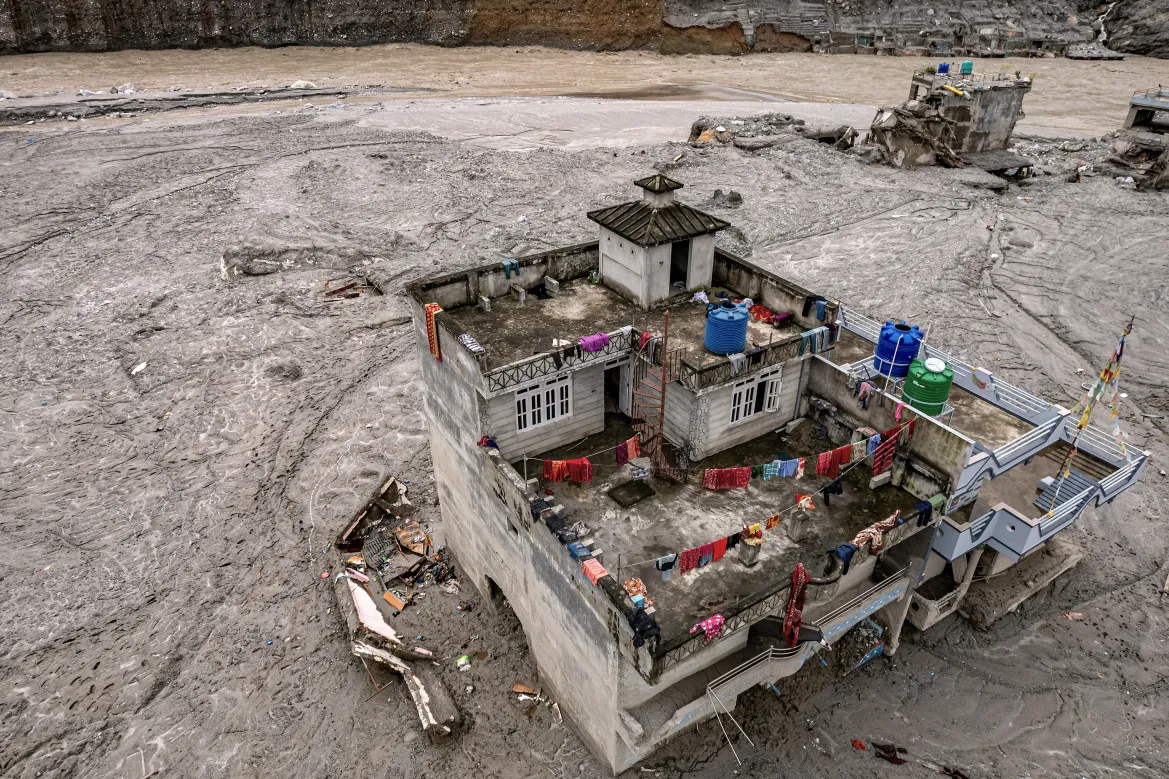
On the morning of 26 August, part of the Langtang Lirung glacier broke away near the Nepal-China border. Satellite images later showed a clean, huge break in the ice at around 5,200 metres, the kind of fracture a geoscientist based in Bangladesh described as looking like someone had taken a knife to the whole lower section of the mountain.³ What came down afterward was not simply water. It was ice, rock, and meltwater moving together, hitting the valley with enough force that the resulting tremor registered on seismometers as a magnitude 5.2 event.⁴
At monitoring points along the Trishuli River, water levels rose by as much as nine metres in thirty minutes.⁵ No storm caused that. Scientists were initially unsure whether an earthquake had triggered the collapse or the collapse had triggered the earthquake. It turned out to be the latter.⁶
By early September, more than 1,350 people were confirmed dead in Nepal, with over 5,000 still missing.⁷ Floodwaters carried some victims as far as 240 kilometres downstream, into India.⁸
I want to follow the water past that point, because rivers do not stop at borders. It kept moving, and where it went says something about a country that has, so far, mostly watched this disaster from a distance, the way Durov’s passengers watched the band play.
Where the water actually goes
The Trishuli eventually meets the Kali Gandaki at a town called Devghat, and together they form the Narayani.⁹ The Narayani crosses into India, where the same river takes another name, the Gandak, before it eventually joins the Ganga.¹⁰ Concern over that route was immediate. Communities along the Trishuli and Gandak systems, including areas across the border in India, were flagged for flood risk within hours of the initial collapse.¹¹
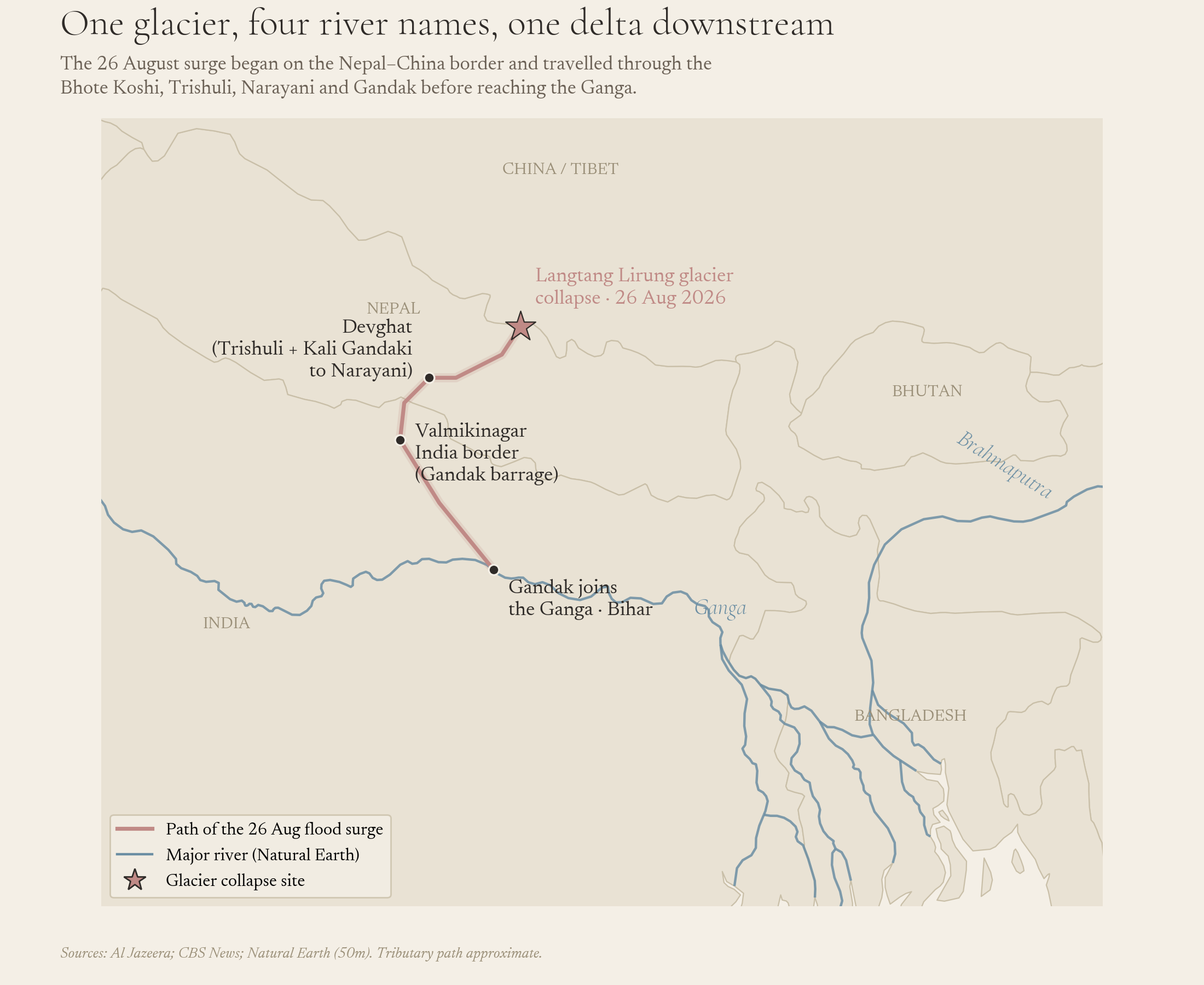
I won’t pretend the water arrived in Bangladesh as a visible wave. By the time this particular surge reached the Ganga, it had already spread across a much wider channel and been substantially absorbed by distance and by flood infrastructure upstream in India. There’s no evidence this specific event produced a flood pulse Bangladesh would have felt. What Bangladesh received instead was something quieter: a demonstration, on camera, of a hazard sitting in the same mountain range as the rivers it depends on.
The same thing has already happened on Bangladesh’s own river
This is the part that gets lost when the story stays framed as Nepal’s disaster alone. The Brahmaputra, which becomes the Jamuna once it enters Bangladesh, begins as the Yarlung Tsangpo on the Tibetan plateau.¹² In October 2018, that exact river was blocked twice within two weeks by glacier collapses in a gorge called Sedongpu, each one sending an estimated 130 million cubic metres of ice and debris into the channel and damming it outright.¹³ It happened again in 2021, a smaller repeat of the same event, in the same gorge.¹⁴
So this isn’t a hazard borrowed from someone else’s misfortune. It has already visited the headwaters of Bangladesh’s own largest river, more than once, within the last decade. The iceberg, in other words, has already been struck. Twice.
Why the frequency isn’t a coincidence
Glaciers across the wider Hindu Kush Himalayan region are now losing ice at roughly twice the rate they were in 2000, according to research from the Kathmandu-based International Centre for Integrated Mountain Development.¹⁵ The region has lost up to 27 metres of ice thickness since 1975, with about 12 percent of its glacier area gone between 1990 and 2020 alone.¹⁶ Those glaciers feed rivers that around 240 million people in the mountains rely on directly, and roughly 1.65 billion people further downstream depend on indirectly.¹⁷
None of that trend depends on any single country changing its behaviour for the risk to keep rising. The ice is already retreating. The only open question is where the next collapse happens, and how much warning anyone downstream gets.
What Bangladesh actually controls here
Bangladesh’s vulnerability here isn’t abstract. Its geography sits at the bottom of a delta shaped by exactly this kind of upstream hazard, low-lying, densely populated, and dependent on rivers whose behaviour is set hundreds or thousands of kilometres away in terrain it cannot monitor.¹⁸ Research on the Brahmaputra basin has noted specifically that meltwater plays a far larger role in that river than in the Ganges, and that the Brahmaputra’s delta sits near Dhaka.¹⁹ A 2020 hazard assessment projected that flood frequency across the lower Ganges and Brahmaputra basins would climb through this century, with roughly 220 million people’s livelihoods affected.²⁰
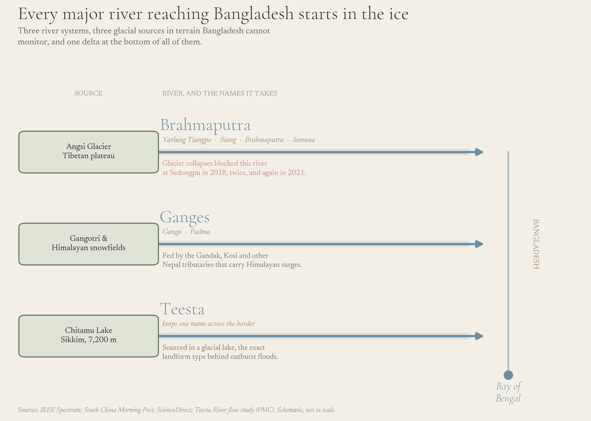
What’s missing is not diplomatic leverage. It’s instrumentation. The 2018 and 2021 Sedongpu collapses happened on the river that becomes Bangladesh’s Jamuna, and there is no evidence Bangladesh had any independent early warning of either one. Building that capacity, satellite monitoring of glacial lakes, sensor networks upstream on shared tributaries like the Teesta, treating glacial-origin floods as a distinct hazard from monsoon floods, doesn’t require another country’s permission. It requires deciding the mountain is already part of the story, not just Nepal’s.
Durov’s point about the Titanic was that the danger was never really about the size of the iceberg. It was about the thirty minutes between when people could still act and when they finally did.²¹ Bangladesh’s rivers have already told it, twice, where the next iceberg tends to form. What it does with those thirty minutes is still an open question.
Sources
- Pavel Durov in Oslo: on the loss of freedoms, mass surveillance, and censorship, Oslo Freedom Forum speech transcript
- Oslo Freedom Forum speech transcript, as above
- Deadly Nepal flood highlights glacier risks in warming Himalayas, CBS News
- 2026 Nepal–Tibet floods, Wikipedia (citing BBC News reporting)
- Nepal-Tibet floods: What happened, what caused them and who is missing?, Al Jazeera
- In Nepal’s Tragedy, a Warning for a Warming World, TIME
- 2026 Nepal–Tibet floods, Wikipedia
- 2026 Nepal floods, Wikipedia
- Nepal-Tibet floods: What happened…, Al Jazeera
- Nepal-Tibet floods: What happened…, Al Jazeera
- Nepal-Tibet floods: What happened…, Al Jazeera
- Warming Effects on the Major Asian Rivers, IEEE Spectrum
- Melting glaciers threaten China’s plan to build megadam in Tibet, South China Morning Post
- Process, mechanisms, and early warning of glacier collapse-induced river blocking disasters in the Yarlung Tsangpo Grand Canyon, ScienceDirect
- Himalayan glaciers melting twice as fast, putting water supplies for nearly two billion people at risk, AFP (via Malay Mail)
- AFP (via Malay Mail), as above
- Deadly Nepal flood highlights glacier risks in warming Himalayas, CBS News
- Climate change in Bangladesh, Wikipedia
- Warming Effects on the Major Asian Rivers, IEEE Spectrum
- Hazard from Himalayan glacier lake outburst floods, PNAS
- Oslo Freedom Forum speech transcript